
GIS-based spatio-temporal analysis of surface elevations in a waste disposal
Geoinformation System (GIS) has completely changed the outlook on Earth’s monitoring system. The data from the real world is converted into digital form and a subsequent model is created. The model then can be analyzed and interpreted. GIS utilizes the Global Navigation Satellite System (GNSS) data. GNSS contains the system of satellite revolution around the earth. GNSS data includes the time and position of the object throughout the entire earth.
The geospatial data or the GNSS data from satellites do not always cover the whole area and only a certain number of point data is given in the given area. Given that it is practically impossible to take measurements of all the required regions, interpolation techniques become instrumental in the estimation of unknown points, based on the known points. The estimated values from the interpolation methods are significant for data processing, data modeling, and data analysis. There are many interpolation methods used in GIS such as Triangulated Irregular Network (TIN) interpolation, Spline, Kriging, Natural Neighbor, Inverse Distance Weighted (IDW), etc.
Moreover, the monitoring of surface elevations through GIS has gained a significant reputation for delivering consistent results and for being convenient as well.
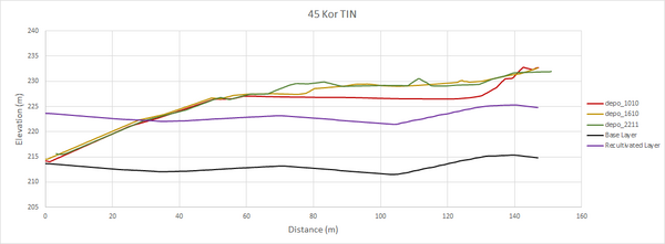
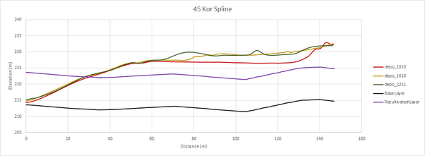
This thesis presents a comprehensive investigation into the spatio-temporal dynamics of the surface elevations using GIS, in a waste disposal site in “Kirschenplantage”, located in the Kassel district of Germany. In GIS, two interpolation techniques are applied to convert GNSS data into a Digital Terrain Model (DTM). Then the core of the research involves DTM analysis of the Kirschenplanatage waste disposal site by focusing on visualizing DTMs, calculating surface elevation profiles, and calculating surface volume. The visualization of the DTMs and surface elevation profiles provides insights into the surface variations. Furthermore, time series analysis based on GNSS data illustrates yearly changes in topography.
The study finds that waste elevation increases from the south to the north of the disposal site, and the various interpolation methods produce relatively consistent results.
This research adds significant value to the field of waste disposal management by utilizing the capabilities of GIS for spatio-temporal analysis. It empowers decision-makers and environmental planners with tools to monitor, manage, and reduce the impacts of surface elevation changes in waste disposal sites.
Bearbeiter:
B.Sc. Muneeb Ahmed
Betreuer:
Yu Lan
1. Gutachter und Betreuer:
Prof. Dr. Jens-André Paffenholz
2. Gutachter:
Prof. Dr.-Ing. Oliver Langefeld